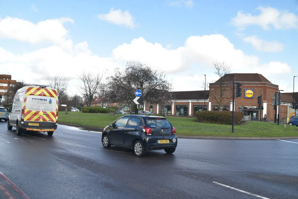

Two-way lights on the A232 Acre Lane from 24 October to 1 November. SGN's Mill Lane gas dig runs to 13 December, Buckingham Way now to 17 December.
Getting around Sutton means dealing with two road authorities and whatever the utility companies have dug up this week. London’s official register lists 206 separate roadworks permits in the borough between 21 October and 30 November. This page keeps the picture straight: what is genuinely disrupting travel now, who actually runs each road (the fact that saves the wasted phone calls), and the live maps that always have the current answer between our updates.
What is disrupting travel now (checked 21 October 2026)
On the red routes, the job to plan around is on Acre Lane. TfL lists two-way signals on the A232 Acre Lane at the junction with Manor Road, in both directions, from 24 October to 1 November, for water works (TfL road disruptions). Two more red-route items are on TfL’s list:
- A24 London Road at Langley Avenue: three-phase temporary signals for cable connection works, from 22:00 on 26 October to 20:00 on 27 October. The register also carries a permit for multi-phase signals on London Road, Langley Avenue and Covey Road from 29 October to 1 November, for a new feeder pillar and cable.
- A297 St Helier Avenue, between Boxley Road and Newhouse Walk: various lane closures in both directions from 9 November 2026 to 11 February 2027, for footway and drainage works. TfL tags this stretch to Merton.
The biggest dig on borough roads is still on Mill Lane. SGN is replacing 400 metres of 12-inch iron gas main with new plastic pipe. Its permit runs from 30 August to 13 December (LondonWorks register). London’s register lists 206 permits in the borough between 21 October and 30 November.
Gas main replacement on borough roads, on the register’s dates:
- Buckingham Way, 470 metres and 58 services, now to 17 December (it was 27 November when we last checked)
- Mollison Drive, about 450 metres of 10-inch iron main, to 6 December, with works compounds on Lindbergh Road (to 15 November) and Lancastrian Road (16 November to 6 December)
- Carew Road, 330 metres and 47 services, to 13 November
- Garden Close, 165 metres and 24 services, to 13 November
- The Ridge, 450 metres, to 27 October
- Clifton Road and Park Road, about 310 metres each, to 22 October
- Stanley Park Road, 90 metres of new main and 20 services, 26 October to 20 November
- Clyde Road, 70 metres, 2 to 20 November
- Melbourne Road, 186 metres and 77 services, 16 November to 24 December
- Alington Grove, Bridge Road and Stratton Avenue, 65 to 110 metres each, from 16 November to mid-December, and Oxford Road, 103 metres, 23 November to 11 December
SGN also has emergency gas escape repairs open this week on the High Street, Camborne Road, Manor Place, Lenham Road and Wrythe Lane. On Harrow Road it digs three trial holes under multi-way lights from 16 to 29 November, ahead of replacing a gas governor.
Water and sewers. Thames Water is digging about 2 metres down on Sparrow Farm Road to repair two collapses in the sewer, one in the road and one in the footway, from 19 to 30 October. Its sewer jobs on Beresford Road and Rosehill Avenue are due to finish on 22 October. SES Water has leak repairs open on Arundel Road, Bute Road, Egmont Road, Mulgrave Road, Southway, The Avenue and The Downsway this week.
Power. UK Power Networks installs a new supply on Sutton Common Road to 26 October, with a bus stop suspended. Three of its link box replacements need the road closed:
- Selwood Road, 2 to 6 November, with the dig reaching the footway of Sutton Common Road
- Bramblewood Close and Tweeddale Road, 30 November to 4 December
Council works. The council is improving the northern footway of Rose Hill, with new kerbs and paving, to 3 November. It is also laying air-quality monitoring station ducting on Beddington Lane and Woodcote Road from 20 to 27 October. Its resurfacing programme has these dates (council planned resurfacing):
- Winchcombe Road, Waltham Road to Wrythe Lane, 26 to 28 October
- Wigmore Road, 28 to 29 October
- Knolls Close, 30 October
- Strathearn Road, 30 November
- Clyde Road, 1 December
- Court Drive, 2 December
- Prior Avenue, 3 to 4 December
The council writes to affected residents 5 to 10 working days before resurfacing starts. EE has a road closure on Green Wrythe Crescent on 26 November for work on a telecoms mast, with two-way lights on Green Wrythe Lane.
Short-dated digs on residential roads change weekly; the live maps below are the authority on the day.
Who runs which road
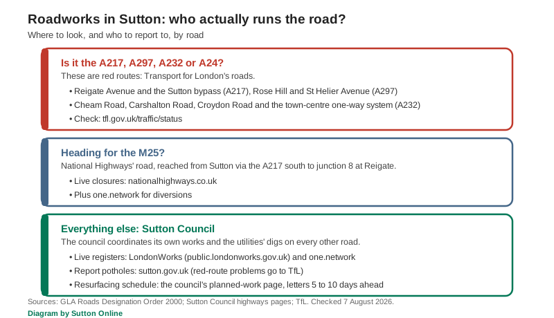
This is the evergreen fact worth keeping. Sutton’s main corridors are red routes, and red routes belong to Transport for London, not the council. The legal list (GLA Roads Designation Order 2000) gives TfL: the A217 from the boundary up Belmont Rise and Reigate Avenue, the Sutton bypass, to the Rosehill roundabout; the A297 Rose Hill and St Helier Avenue onwards to Morden; the A24 through North Cheam and down Stonecot Hill; and the A232 right across the borough, Cheam Road, Carshalton Road and Croydon Road, including the town-centre one-way system’s Chalk Pit Way, Grove Road, Sutton Court Road and Sutton Park Road, plus the linking stretch of the B2230 High Street and Brighton Road. In other words, the whole Sutton gyratory is TfL’s road, which surprises most residents.
Every other road, Sutton Common Road, Gander Green Lane, Wrythe Lane, Stafford Road and the rest, is maintained by Sutton Council, which schedules its own works and permits the utilities. Potholes on borough roads go to the council’s reporting page; problems on the red routes go to TfL’s streets contact page, which is where the council’s own page sends you. The M25 is National Highways’ road, reached from Sutton via the A217 south to junction 8 at Reigate.
The live maps that always have the answer
Roadworks lists date fast; these do not.
- LondonWorks is London’s official roadworks register, searchable by borough with every live and planned permit; it is where the council’s streetworks register page sends residents (public.londonworks.gov.uk).
- one.network shows the same digs on a live map, linked from the council’s street works page (one.network).
- TfL traffic status covers the A217, A297, A232 and A24 red routes and everything London-wide (tfl.gov.uk/traffic/status).
- National Highways covers the M25 (live travel updates).
- The council’s resurfacing schedule lists each street and start date for the year’s programme (planned work).
Rails, and the schemes that shape the roads
When the roads clog, Sutton’s answer is usually the train: four Southern trains an hour to Victoria and four Thameslink trains through the City off-peak, with times, fares and caps in our trains to London guide. Engineering work does intervene. Coming up:
- Sunday 25 October: no Thameslink trains between Finsbury Park or St Pancras and London Bridge or Sutton, because all lines between St Pancras and Blackfriars close. Tickets are accepted on Southern trains to Sutton, South Western Railway to Wimbledon, London Buses, trams and the Underground (National Rail).
- Sunday 1 November: buses replace Southern trains between Epsom and Dorking, because all lines close between Epsom and Dorking and Effingham Junction (National Rail).
- Monday 2 to Friday 6 November: from about 00:10 to 05:00 on the Tuesday to Friday mornings, late Thameslink trains to and from Sutton do not run between Blackfriars or Herne Hill and Sutton. Paper tickets are accepted on London Buses (National Rail).
- Sunday 8 November: the 08:40 and 09:10 London Bridge to Sutton Thameslink trains start from Blackfriars instead, and do not call at London Bridge or Peckham Rye (National Rail).
- Tuesday 17 to Friday 20 November: no Thameslink trains between Herne Hill and Sutton from about 00:25 to 05:35, because all lines close. Southern accepts Thameslink tickets, and paper tickets are accepted on London Buses and the Underground (National Rail).
- Sunday 29 November: buses replace Southern trains between Sutton and Epsom or Dorking, because lines are closed between Raynes Park and Leatherhead (National Rail).
Check future engineering works before travelling. If you drive to the station, Sutton’s 205-space APCOA car park runs 24/7 on number-plate recognition, free for Blue Badge holders (National Rail: Sutton station); the borough has no park-and-ride, so the alternative is the town-centre car parks in our parking guide.
Two bigger stories set the long-term picture. The Sutton Link tram extension is dead: TfL shelved it in September 2023 when the estimate reached £560 million against a budget of under £120 million, and its current five-year plan contains no tram extensions (Inside Croydon). Meanwhile the Beddington North major scheme, funded with TfL, is working through improvements to Beddington Lane and Hilliers Lane, junctions, crossings and the tram-stop area, to cut congestion on the borough’s industrial north-east corner (Sutton Council).
Frequently asked questions
What roadworks are happening in Sutton right now?
On the red routes, TfL has two-way signals on the A232 Acre Lane at Manor Road from 24 October to 1 November. On borough roads the main one is SGN’s 400-metre gas main replacement on Mill Lane, which runs to 13 December, with further SGN mains on Buckingham Way (to 17 December), Mollison Drive (to 6 December) and Carew Road (to 13 November). Thames Water is repairing two sewer collapses on Sparrow Farm Road to 30 October. The A297 St Helier Avenue lane closures start on 9 November. For today’s picture, check LondonWorks or one.network, which list every permitted dig.
Who is responsible for the A217 and the Sutton one-way system?
Transport for London. The A217, the A297 Rose Hill and St Helier Avenue, the A24 at North Cheam and the whole A232 corridor including the town-centre one-way system are red routes under the GLA Roads Designation Order 2000. Everything else is Sutton Council’s.
How do I report a pothole in Sutton?
On borough roads, through the council’s pothole reporting page. On the red routes (A217, A297, A232, A24), report to TfL instead.
Is Sutton getting a tram?
No. TfL dropped the Sutton Link extension in September 2023 on cost grounds, and no tram scheme appears in its current investment plan (Inside Croydon). The nearest tram stops remain on the borough’s north-east edge at Beddington Lane.
Sources
- LondonWorks roadworks register, borough of Sutton (Mill Lane, Buckingham Way, Mollison Drive and other gas mains, SES Water leaks, Thames Water sewer works, UK Power Networks link boxes, council footway and air-quality works, 206 permits for 21 October to 30 November)
- Sutton Council: planned resurfacing work (2026-27 programme and dates) and streetworks register
- TfL road disruptions and TfL traffic status (A24 London Road, A232 Acre Lane, A297 St Helier Avenue)
- GLA Roads Designation Order 2000 (which Sutton roads are TfL’s) and Sutton Council: report potholes
- National Rail: Thameslink on 25 October, Epsom to Dorking on 1 November, Thameslink overnight, 2 to 6 November, London Bridge to Sutton on 8 November, Thameslink overnight, 17 to 20 November, Raynes Park to Leatherhead on 29 November and Sutton station facilities
- Inside Croydon: TfL bins the £560m Sutton Link and Sutton Council: Beddington North major scheme
Roadworks dates change at short notice; the live maps above are the authority on the day. Our other guides cover trains to London, parking in Sutton and Sutton bin collection days. Last checked 21 October 2026.
Have your say