
Sutton scores 1.79 out of 10 on the 2026 Healthy Streets Scorecard, unchanged and 30th of 33. Bus priority reaches 4.1% of routes. One measure is London's best.
Sutton is 30th of London’s 33 boroughs on the 2026 Healthy Streets Scorecard, with a score of 1.79 out of 10 that has not moved since last year. The scorecard is published annually by a coalition of transport and environment charities, and its 2026 edition went up in early July (Healthy Streets Scorecard: Sutton).
That ranking matters locally this week, because the Hackbridge, St Helier and The Wrythe Local Committee meets tomorrow evening and the last two items on its agenda are a “Highways and Transport Overview and TfL Programme for 2027/28” and the Neighbourhood Fund. The council has published no report against either (agenda, 17 September 2026).
The six things the borough has not built
The scorecard splits into six input indicators, which measure what a council has actually put on the ground, and four outcome indicators, which measure how people travel. Sutton’s input scores are its weakest.
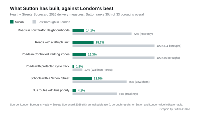
- Low Traffic Neighbourhood coverage is unchanged at 14.1 per cent of streets. Hackney’s is 72 per cent.
- 20mph limits cover 25.7 per cent of borough roads. Eleven London boroughs are on 100 per cent.
- Controlled Parking Zones cover 16.3 per cent of roads.
- Protected cycle track fell to 1.8 per cent, which the scorecard attributes to a correction in its mapping rather than track being removed.
- School Streets cover 23.5 per cent of schools, 16 in total on the scorecard’s count.
- Bus priority reaches 4.1 per cent of bus route distance. This is the starkest gap of the six.
On the outcome side, cycling participation fell to 8.4 per cent of adults cycling at least once a week, and the scorecard records Sutton as having one of London’s highest cyclist casualty rates. Only 26.0 per cent of households in the borough have no car.
What did get better
The same page records movement in the right direction on four outcome measures, and they are worth saying plainly because they are the part a council cannot simply build:
- sustainable modeshare rose from 45.8 to 47.2 per cent of journeys made by public transport, walking or cycling, although that remains one of the lowest figures in London
- the share of adults walking regularly rose to 30.3 per cent
- Travel for Life participation improved to 28.3 per cent of schools
- the polluting-vehicle score improved from 6.51 to 6.30
And on one London-wide measure Sutton is first out of 33. The borough has the lowest proportion of diesel cars in London, at 12 per cent, against 20 per cent in Barking and Dagenham.
The part of the problem the council does not own
Anyone reading the bus priority and cycle track figures should hold one fact alongside them. Sutton’s busiest corridors are red routes, and red routes belong to Transport for London, not the council. That covers the A217, the A297 Rose Hill and St Helier Avenue, the A24 through North Cheam, and the whole A232 across the borough including the town-centre one-way system, under the GLA Roads Designation Order 2000. We set out the full split in our Sutton roadworks and travel guide.
For the first time, the scorecard coalition scored those TfL roads separately. Across London’s red routes in the last year it found increases in 20mph limits and bus lanes, no increase in protected cycle track, no reduction in traffic, and a 2.4 per cent rise in serious and fatal casualties (2026 results overview).
So a fair reading is that the borough’s worst-scoring streets are split between two authorities, and neither is moving fast.
What the council has done on School Streets
The council’s own page lists 13 School Street schemes in operation, some covering more than one school (Sutton School Streets):
- Abbey Primary School
- All Saints Carshalton Church of England Primary School
- Cheam Common Junior and Infants Academy
- Cheam Fields Primary Academy
- Cheam Park Farm Primary Academy
- The Federation of St Elphege’s Catholic Schools
- Harris Junior Academy Carshalton
- Muschamp Primary School
- Robin Hood Junior School
- Robin Hood Infants and Thomas Wall Nursery
- Tweeddale Primary School and Tweeddale Children’s Centre
- St Philomena’s Catholic High School for Girls and St Mary’s Catholic Junior School
- Wood Field and Oak Field Primary School
Restrictions run during term time only, at times that vary by school, and are enforced by number plate recognition cameras. Residents inside a zone, blue badge holders, carers, school staff, refuse vehicles and the emergency services can all enter.
What it means for you
If you want the borough’s transport programme changed, the next chance to say so in person is tomorrow, Thursday 17 September, at 7pm at Horizon Church, Assembly Walk, Carshalton SM5 1JH. The committee takes public questions.
The deadline for a written answer before the meeting has passed: the council gives that only to questions submitted at least five working days ahead. A question submitted now still gets a written response, but after the meeting. Questions go through the form on the council’s website, and are published with your name.
At the committee’s last meeting in July, one resident’s supplementary question noted a street defect that had been outstanding for over 900 days without a completion date. The Director of Finance undertook to respond outside the meeting (minutes, 2 July 2026).
The Neighbourhood Fund item on tomorrow’s agenda is the third local committee running to carry one without a published paper, which we covered in our piece on the missing project lists. Officers told the July meeting that 15 per cent of the money raised through the Community Infrastructure Levy is ringfenced for local projects through that fund, and that only new projects can be funded, not existing ones.
Sources
- Healthy Streets Scorecard 2026: Sutton borough results (rank, score, all ten indicators)
- Healthy Streets Scorecard 2026: results overview (best and worst borough on each indicator, the TfL red route report)
- Sutton Council: how School Streets work (the 13 schemes and the exemptions)
- Hackbridge, St Helier and The Wrythe Local Committee, agenda and July minutes, 17 September 2026
- GLA Roads Designation Order 2000 (which Sutton roads are TfL’s)
More on getting around the borough: roadworks and travel, trains to London and parking in Sutton.
Have your say