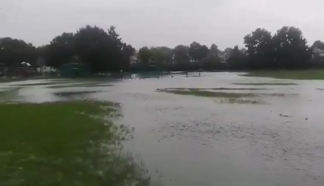

The Cuddington Rec flood scheme in Worcester Park is built bar landscaping: 3,400 cubic metres of storm storage for 199 homes. What changed in the park.
Worcester Park’s new flood defence at Cuddington Recreation Ground is built. The council says the scheme is “now functionally complete with just some landscaping elements to complete”.
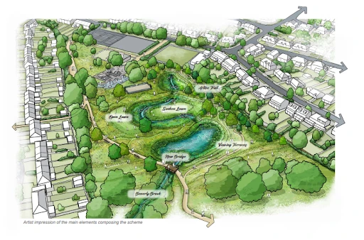
It will hold about 3,400 cubic metres of storm water in a new wetland and two basins. The council says 199 properties downstream will benefit.
The update is in a flood risk report to Sutton’s Scrutiny Committee on Wednesday 21 October (Flood Risk Management Update). Thames Water and the Environment Agency have been invited to answer councillors’ questions.
Why Worcester Park needed it
The council calls Worcester Park the most at-risk critical drainage area in the borough. On 25 July 2021, 41 properties there were reported as flooded inside (Sutton Council).
The Met Office had issued an amber thunderstorm warning that day. The rain that fell in one hour had a return period of 118 years, according to the council’s report. In other words, a downpour that heavy has roughly a 1 in 118 chance of happening in any one year.
The new scheme is designed to store a similar amount of water to that storm. It adds to an earlier scheme on Green Lane, finished in 2014.
What has been built
The scheme works by catching runoff in the park before it reaches the drains in the streets below. The water then drains back into the Thames Water main sewer at a slower rate. The main parts are:
- an opened-up stretch of the Beverley Brook, which had run in a culvert under the park
- a permanent wetland, fenced while the planting establishes
- two basins that fill only in heavy storms and stay usable as open ground the rest of the time
- a new bridge carrying the existing path over the brook, strong enough for maintenance vehicles
- a multi-user route to the east, over landforms made from the earth dug out on site
- a new land drain to deal with groundwater coming up in back gardens on St Clair Drive
Building started in May. The contractor maintains the works for two years, after which the council’s parks team takes over. Meadow seeding and trees go in once ground and weather allow, or in spring 2027 if not.
The council’s scheme page, written before work started, put the storage at about 4,000 cubic metres and the homes helped at around 200. The committee report gives the later figures of 3,400 cubic metres and 199 properties.
Flood risk across the borough
The report puts the wider risk in numbers:
- 1,866 properties in the borough are at high risk of flooding, according to the council’s flood strategy
- 70% of property flooding in Sutton has happened in June or July, when summer thunderstorms overwhelm the drains
- Substantial flooding hit the borough in 2016, 2017, 2021 and 2024
- On 23 September 2024, nine properties beside the River Wandle in Hackbridge flooded inside, after 58.2mm of rain in 24 hours. The average for a whole month is 50mm.
The council has 16,573 road gullies. Its contractor, FM Conway, has cleaned 3,784 of them since April. Sensors fitted to 18 gullies in known trouble spots now alert officers when water builds up.
What comes next
The Beddington area is next. It takes in the Manor Road underpass at Wallington station and Demesne Road, but homes flooded inside at Beddington Gardens come first. Outline designs for sustainable drainage are drawn up. But the report warns the lack of open space and narrow roads “greatly constrains options for solving the issues in this area”.
At Belmont, flooding has cut off access to the station every year, and Southern trains have not stopped there when it floods. A new rain garden has been built at Station Approach and drainage on Brighton Road repaired. The council says it is still reviewing whether more work is needed.
The report also flags a funding risk. The Environment Agency is changing its funding criteria from 2026/27. That will not affect schemes already under way, but “could impact future schemes”.
What it means for you
- If you live downstream of Cuddington Rec, the scheme should cut how often the Beverley Brook overflows in a summer storm. It does not remove the risk.
- Parts of the park are still fenced. The wetland stays fenced while its plants establish. The basins can be used as open ground except when they are holding water.
- Sign up for flood warnings. The Environment Agency’s free service sends alerts by phone, text or email (GOV.UK).
- Report flooding or a blocked gully to the council through its flooding pages.
- Watch the meeting. The Scrutiny Committee meets at 7.30pm on Wednesday 21 October at the Civic Offices, St Nicholas Way (agenda).
Have your say